
Göteborgs Stad topographic map
Interactive map
Click on the map to display elevation.
About this map
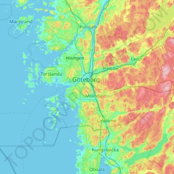
Name: Göteborgs Stad topographic map, elevation, terrain.
Location: Göteborgs Stad, Comté de Västra Götaland, Suède (57.49966 11.23156 57.86596 12.24183)
Average elevation: 44 m
Minimum elevation: -3 m
Maximum elevation: 213 m
Pour la topographie, l'histoire, la culture, l'économie, etc., voir l'article Göteborg.
Other topographic maps
Click on a map to view its topography, its elevation and its terrain.
Vara kommun
Suède > Comté de Västra Götaland
Vara kommun, Comté de Västra Götaland, Suède
Average elevation: 102 m
Ale kommun
Suède > Comté de Västra Götaland
Ale kommun, Comté de Västra Götaland, Suède
Average elevation: 92 m
Tibro kommun
Suède > Comté de Västra Götaland
Tibro kommun, Comté de Västra Götaland, Suède
Average elevation: 129 m