
Ale kommun topographic map
Interactive map
Click on the map to display elevation.
About this map
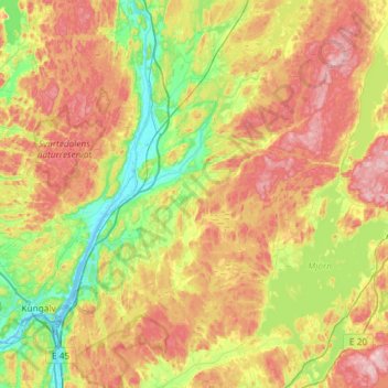
Name: Ale kommun topographic map, elevation, terrain.
Location: Ale kommun, Comté de Västra Götaland, Suède (57.80626 12.00759 58.11804 12.43470)
Average elevation: 92 m
Minimum elevation: -3 m
Maximum elevation: 221 m
Other topographic maps
Click on a map to view its topography, its elevation and its terrain.
Göteborgs Stad
Suède > Comté de Västra Götaland
Göteborgs Stad, Comté de Västra Götaland, Suède
Average elevation: 44 m
Vara kommun
Suède > Comté de Västra Götaland
Vara kommun, Comté de Västra Götaland, Suède
Average elevation: 102 m
Tibro kommun
Suède > Comté de Västra Götaland
Tibro kommun, Comté de Västra Götaland, Suède
Average elevation: 129 m