
Karimun topographic map
Interactive map
Click on the map to display elevation.
About this map
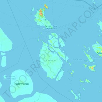
Name: Karimun topographic map, elevation, terrain.
Location: Karimun, Riau Islands, Indonesia (0.47247 103.28438 1.19170 103.98049)
Average elevation: 3 m
Minimum elevation: -2 m
Maximum elevation: 387 m
Other topographic maps
Click on a map to view its topography, its elevation and its terrain.
Citra Indah
Indonesia > Riau Islands > Batam City > Teluk Tering
Citra Indah, Teluk Tering, Batam City, Riau Islands, 29456, Indonesia
Average elevation: 18 m
Pangkalan Petai
Indonesia > Riau Islands > Batam City
Pangkalan Petai, Batam City, Riau Islands, 29462, Indonesia
Average elevation: 27 m
Bintan Island
Indonesia > Riau Islands > Tanjung Pinang
Bintan Island, Tanjung Pinang, Riau Islands, Indonesia
Average elevation: 6 m