
Pangkalan Petai topographic map
Interactive map
Click on the map to display elevation.
About this map
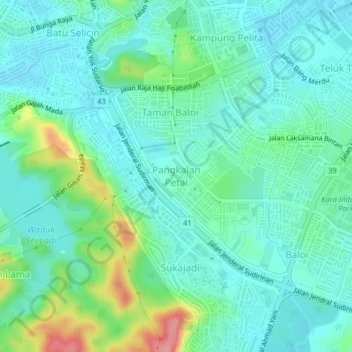
Name: Pangkalan Petai topographic map, elevation, terrain.
Location: Pangkalan Petai, Batam City, Riau Islands, 29462, Indonesia (1.09485 104.00661 1.13485 104.04661)
Average elevation: 27 m
Minimum elevation: 1 m
Maximum elevation: 108 m
Other topographic maps
Click on a map to view its topography, its elevation and its terrain.
Citra Indah
Indonesia > Riau Islands > Batam City > Teluk Tering
Citra Indah, Teluk Tering, Batam City, Riau Islands, 29456, Indonesia
Average elevation: 18 m