
Eisenhüttenstadt topographic map
Interactive map
Click on the map to display elevation.
About this map
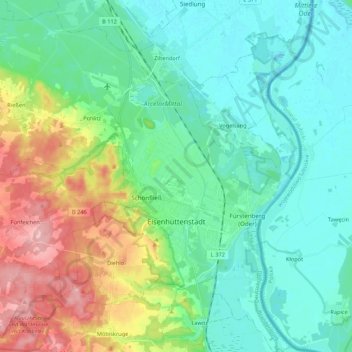
Name: Eisenhüttenstadt topographic map, elevation, terrain.
Location: Eisenhüttenstadt, Oder-Spree, Brandenburg, 15890, Germany (52.09568 14.56538 52.22790 14.70557)
Average elevation: 58 m
Minimum elevation: 21 m
Maximum elevation: 159 m
Other topographic maps
Click on a map to view its topography, its elevation and its terrain.
Graubünden
Germany > Brandenburg > Oder-Spree > Woltersdorf > Schönblick
Graubünden, Demos, Schönblick, Woltersdorf, Oder-Spree, Brandenburg, 15569, Germany
Average elevation: 52 m
Grunow-Dammendorf
Germany > Brandenburg > Oder-Spree
Grunow-Dammendorf, Schlaubetal, Oder-Spree, Brandenburg, Germany
Average elevation: 95 m
Spreenhagen
Germany > Brandenburg > Oder-Spree > Spreenhagen
Spreenhagen, Oder-Spree, Brandenburg, 15528, Germany
Average elevation: 40 m