
Abbey St. Bathans topographic map
Interactive map
Click on the map to display elevation.
About this map
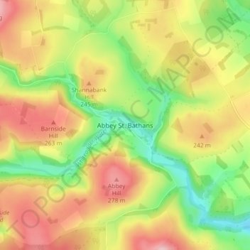
Name: Abbey St. Bathans topographic map, elevation, terrain.
Average elevation: 212 m
Minimum elevation: 128 m
Maximum elevation: 296 m
Abbey St Bathans (Scottish Gaelic: Abaid Bhaoithin) is a parish in the Lammermuir district of Berwickshire, in the eastern part of the Scottish Borders. Unique in its topography, it is situated in a long winding steep wooded valley that follows the Whiteadder Water. The parish had a population of 106 at the 2011 Census.
Other topographic maps
Click on a map to view its topography, its elevation and its terrain.
Stow
United Kingdom > Scotland > Scottish Borders
Stow, Scottish Borders, Scotland, TD1 2RE, United Kingdom
Average elevation: 268 m
Blacklaw
United Kingdom > Scotland > Scottish Borders
Blacklaw, Scottish Borders, Scotland, ML12 6QR, United Kingdom
Average elevation: 360 m
West Linton
United Kingdom > Scotland > Scottish Borders
West Linton, Scottish Borders, Scotland, EH46 7ED, United Kingdom
Average elevation: 264 m
Cappercleuch
United Kingdom > Scotland > Scottish Borders
Cappercleuch, Scottish Borders, Scotland, TD7 5LG, United Kingdom
Average elevation: 378 m
Roberton
United Kingdom > Scotland > Scottish Borders > Roberton
Roberton, Scottish Borders, Scotland, TD9 7LX, United Kingdom
Average elevation: 244 m
Kelso
United Kingdom > Scotland > Scottish Borders
Kelso, Scottish Borders, Scotland, TD5 7HG, United Kingdom
Average elevation: 79 m