
Blauen topographic map
Click on the map to display elevation.
Blauen
In the 14th century, the mountain was recorded as the Blauwen or Blawen. Matthäus Merian's Topographia Sueviae in the mid-17th century calls it the Hoche Blawen ("High Blawen"). The parish boundary plan of the first Baden state survey of 1769/1770 distinguishes between the Hoch Blauen ("High Blauen") and the Hinter Blauen ("Posterior Blauen"), a 1,087-metre-high (3,565 ft) sub-peak, 700 metres (2,295 ft) north-northeast of the main summit. As the Blauen M[ons] the mountain is shown on the Black Forest map owned by St. Blaise Abbey dating to the year 1788. And in 1845 in the Topographischen Atlas ueber das Grossherzogtum Baden ("Topographic Atlas of the Grand Duchy of Baden") it is called the Blauen, as in other geographical publications of the 19th century. In addition in 19th century travel literature the name Hochblauen occurs frequently, sometimes with the explanation that this is to distinguish it from the Zeller Blauen, 12 kilometres (7 mi) away. In fact, the name Hochblauen was normal for the latter on as shown on topographic maps of the time, while the mountain near Badenweiler can still be found on maps today as the Blauen.
About this map
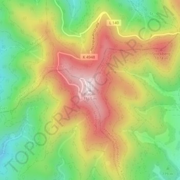
Name: Blauen topographic map, elevation, terrain.
Average elevation: 877 m
Minimum elevation: 613 m
Maximum elevation: 1,161 m
Other topographic maps
Click on a map to view its topography, its elevation and its terrain.
Lörrach (Kernstadt)
Germany > Baden-Württemberg > Landkreis Lörrach > Untertüllingen
Average elevation: 349 m
Lörrach (Kernstadt)
Germany > Baden-Württemberg > Landkreis Lörrach > Untertüllingen
Average elevation: 349 m