
Thank you for supporting this site ❤️
Make a donation
Make a donation
Tumbalá topographic map
Click on the map to display elevation.
Thank you for supporting this site ❤️
Make a donation
Make a donation
About this map
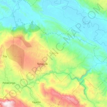
Name: Tumbalá topographic map, elevation, terrain.
Location: Tumbalá, Chiapas, Mexico (17.20948 -92.40319 17.40642 -92.08841)
Average elevation: 674 m
Minimum elevation: 43 m
Maximum elevation: 2,465 m
Thank you for supporting this site ❤️
Make a donation
Make a donation
Other topographic maps
Click on a map to view its topography, its elevation and its terrain.