
Melle topographic map
Interactive map
Click on the map to display elevation.
About this map
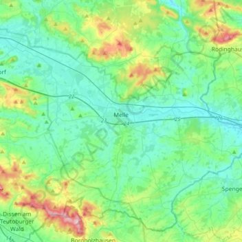
Name: Melle topographic map, elevation, terrain.
Location: Melle, Landkreis Osnabrück, Nedersaksen, Duitsland (52.10795 8.20305 52.28313 8.51731)
Average elevation: 117 m
Minimum elevation: 64 m
Maximum elevation: 301 m
Other topographic maps
Click on a map to view its topography, its elevation and its terrain.
Grambergen
Duitsland > Nedersaksen > Landkreis Osnabrück > Bissendorf
Grambergen, Bissendorf, Landkreis Osnabrück, Nedersaksen, Duitsland
Average elevation: 126 m
Bippen
Duitsland > Nedersaksen > Landkreis Osnabrück
Bippen, Samtgemeinde Fürstenau, Landkreis Osnabrück, Nedersaksen, Duitsland
Average elevation: 63 m
Hunteburg
Duitsland > Nedersaksen > Landkreis Osnabrück > Bohmte
Hunteburg, Bohmte, Landkreis Osnabrück, Nedersaksen, Duitsland
Average elevation: 43 m
Quakenbrück
Duitsland > Nedersaksen > Landkreis Osnabrück > Quakenbrück
Quakenbrück, Artland, Landkreis Osnabrück, Nedersaksen, 49610, Duitsland
Average elevation: 25 m