
Kinlocheil topographic map
Interactive map
Click on the map to display elevation.
About this map
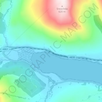
Name: Kinlocheil topographic map, elevation, terrain.
Location: Kinlocheil, Highland, Scotland, PH33 7NP, United Kingdom (56.83894 -5.33590 56.87894 -5.29590)
Average elevation: 135 m
Minimum elevation: -4 m
Maximum elevation: 634 m
Other topographic maps
Click on a map to view its topography, its elevation and its terrain.
Ben Nevis
United Kingdom > Scotland > Highland
Ben Nevis, Highland, Scotland, United Kingdom
Average elevation: 912 m
Fort William
United Kingdom > Scotland > Highland
Fort William, Highland, Scotland, PH33 6AQ, United Kingdom
Average elevation: 122 m
Inverness
United Kingdom > Scotland > Highland
Inverness, Highland, Scotland, IV1 1AN, United Kingdom
Average elevation: 163 m
Staffin
United Kingdom > Scotland > Highland
Staffin, Highland, Scotland, IV51 9HY, United Kingdom
Average elevation: 42 m
Skye
United Kingdom > Scotland > Highland
Skye, Highland, Scotland, United Kingdom
Average elevation: 63 m
Aviemore
United Kingdom > Scotland > Highland
Aviemore, Highland, Scotland, PH22 1RN, United Kingdom
Average elevation: 331 m
Sgùrr na Banachdich
United Kingdom > Scotland > Highland
Sgùrr na Banachdich, Highland, Scotland, IV47 8TA, United Kingdom
Average elevation: 562 m
Kingairloch
United Kingdom > Scotland > Highland
Kingairloch, Ardgour, Highland, Scotland, PH33 7AE, United Kingdom
Average elevation: 201 m
Scotscalder
United Kingdom > Scotland > Highland
Scotscalder, Highland, Scotland, KW12 6XJ, United Kingdom
Average elevation: 72 m
Glencoe
United Kingdom > Scotland > Highland
Glencoe, Highland, Scotland, PH49 4HS, United Kingdom
Average elevation: 114 m
Cape Wrath
United Kingdom > Scotland > Highland
Cape Wrath, Highland, Scotland, United Kingdom
Average elevation: 24 m
Ahmainn Coire Mhic Nobuil
United Kingdom > Scotland > Highland
Ahmainn Coire Mhic Nobuil, Highland, Scotland, United Kingdom
Average elevation: 347 m
Brae Roy Lodge
United Kingdom > Scotland > Highland
Brae Roy Lodge, Highland, Scotland, United Kingdom
Average elevation: 371 m
Beauly
United Kingdom > Scotland > Highland
Beauly, Highland, Scotland, IV4 7BY, United Kingdom
Average elevation: 71 m
Clachtoll
United Kingdom > Scotland > Highland
Clachtoll, Highland, Scotland, IV27 4JD, United Kingdom
Average elevation: 38 m
Harpsdale
United Kingdom > Scotland > Highland
Harpsdale, Highland, Scotland, KW12 6UL, United Kingdom
Average elevation: 64 m
Glen Etive
United Kingdom > Scotland > Highland
Glen Etive, Highland, Scotland, United Kingdom
Average elevation: 477 m
Ballachulish
United Kingdom > Scotland > Highland
Ballachulish, Highland, Scotland, PH49 4JU, United Kingdom
Average elevation: 160 m
Scottish Highlands
United Kingdom > Scotland > Highland
Scottish Highlands, Highland, Scotland, United Kingdom
Average elevation: 907 m
Loch Ness
United Kingdom > Scotland > Highland > Dores
Loch Ness, Dores, Highland, Scotland, PH32 4BN, United Kingdom
Average elevation: 340 m
Glen Pean
United Kingdom > Scotland > Highland
Glen Pean, Highland, Scotland, United Kingdom
Average elevation: 353 m
Loch Einich
United Kingdom > Scotland > Highland
Loch Einich, Highland, Scotland, United Kingdom
Average elevation: 767 m
Coylumbridge
United Kingdom > Scotland > Highland > Aviemore
Coylumbridge, Aviemore, Highland, Scotland, PH22 1QG, United Kingdom
Average elevation: 262 m
Baligill
United Kingdom > Scotland > Highland > Strathy
Baligill, Strathy, Highland, Scotland, KW14 7RZ, United Kingdom
Average elevation: 42 m
Glasnakille
United Kingdom > Scotland > Highland
Glasnakille, Highland, Scotland, IV49 9BQ, United Kingdom
Average elevation: 39 m
Nigg
United Kingdom > Scotland > Highland
Nigg, Highland, Scotland, IV19 1QR, United Kingdom
Average elevation: 49 m
Torran
United Kingdom > Scotland > Highland
Torran, Highland, Scotland, IV40 8PF, United Kingdom
Average elevation: 42 m
Heights of Brae
United Kingdom > Scotland > Highland
Heights of Brae, Highland, Scotland, IV14 9AF, United Kingdom
Average elevation: 182 m
Broadford
United Kingdom > Scotland > Highland
Broadford, Highland, Scotland, IV49 9AD, United Kingdom
Average elevation: 34 m
Kilphedir
United Kingdom > Scotland > Highland
Kilphedir, Highland, Scotland, United Kingdom
Average elevation: 175 m
Kingussie
United Kingdom > Scotland > Highland
Kingussie, Highland, Scotland, PH21 1LQ, United Kingdom
Average elevation: 338 m
Isauld
United Kingdom > Scotland > Highland > Reay
Isauld, Reay, Highland, Scotland, KW14 7RW, United Kingdom
Average elevation: 30 m
Bunacaimb
United Kingdom > Scotland > Highland
Bunacaimb, Highland, Scotland, PH39 4NT, United Kingdom
Average elevation: 19 m
Caol
United Kingdom > Scotland > Highland
Caol, Highland, Scotland, PH33 7EN, United Kingdom
Average elevation: 38 m
Lyth
United Kingdom > Scotland > Highland
Lyth, Highland, Scotland, KW1 4UE, United Kingdom
Average elevation: 29 m
Brora
United Kingdom > Scotland > Highland
Brora, Highland, Scotland, KW9 6NX, United Kingdom
Average elevation: 14 m
Glendoe Reservoir
United Kingdom > Scotland > Highland
Glendoe Reservoir, Highland, Scotland, United Kingdom
Average elevation: 654 m
Dores
United Kingdom > Scotland > Highland
Dores, Highland, Scotland, IV2 6TT, United Kingdom
Average elevation: 106 m
Hill of Rigifa'
United Kingdom > Scotland > Highland
Hill of Rigifa', Highland, Scotland, KW14 8XL, United Kingdom
Average elevation: 57 m
Insh
United Kingdom > Scotland > Highland
Insh, Highland, Scotland, PH21 1NT, United Kingdom
Average elevation: 275 m
Kilchoan
United Kingdom > Scotland > Highland
Kilchoan, Highland, Scotland, PH36 4LH, United Kingdom
Average elevation: 63 m
Loch Ossian
United Kingdom > Scotland > Highland
Loch Ossian, Highland, Scotland, United Kingdom
Average elevation: 538 m
Flodigarry
United Kingdom > Scotland > Highland
Flodigarry, Highland, Scotland, IV51 9HZ, United Kingdom
Average elevation: 90 m
Golspie Burn
United Kingdom > Scotland > Highland > Golspie
Golspie Burn, Golspie, Highland, Scotland, United Kingdom
Average elevation: 148 m
Larach Beag
United Kingdom > Scotland > Highland
Larach Beag, Highland, Scotland, PA80 5XG, United Kingdom
Average elevation: 100 m
Avoch
United Kingdom > Scotland > Highland
Avoch, Highland, Scotland, IV9 8PX, United Kingdom
Average elevation: 50 m
Faillie
United Kingdom > Scotland > Highland > Daviot
Faillie, Daviot, Highland, Scotland, IV2 6XN, United Kingdom
Average elevation: 228 m
Achintee
United Kingdom > Scotland > Highland > Glen Nevis
Achintee, Glen Nevis, Highland, Scotland, PH33 6TE, United Kingdom
Average elevation: 214 m
Castle of Old Wick
United Kingdom > Scotland > Highland > Wick
Castle of Old Wick, Mill Lade Avenue, Harden, Wick, Highland, Scotland, KW1 5BY, United Kingdom
Average elevation: 17 m
Loch of Wester
United Kingdom > Scotland > Highland
Loch of Wester, Highland, Scotland, United Kingdom
Average elevation: 11 m