
Thank you for supporting this site ❤️
Make a donation
Make a donation
Dassel topographic map
Click on the map to display elevation.
Thank you for supporting this site ❤️
Make a donation
Make a donation
About this map
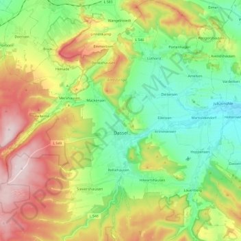
Name: Dassel topographic map, elevation, terrain.
Location: Dassel, Landkreis Northeim, Lower Saxony, 37586, Germany (51.73707 9.57882 51.88157 9.79949)
Average elevation: 277 m
Minimum elevation: 121 m
Maximum elevation: 531 m
Thank you for supporting this site ❤️
Make a donation
Make a donation
Other topographic maps
Click on a map to view its topography, its elevation and its terrain.