
Thank you for supporting this site ❤️
Make a donation
Make a donation
East Devon topographic map
Click on the map to display elevation.
Thank you for supporting this site ❤️
Make a donation
Make a donation
About this map
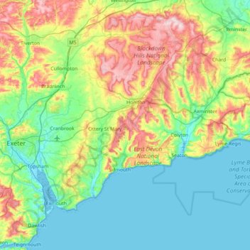
Name: East Devon topographic map, elevation, terrain.
Location: East Devon, Devon, England, United Kingdom (50.60502 -3.58555 50.90875 -2.88664)
Average elevation: 85 m
Minimum elevation: -2 m
Maximum elevation: 311 m
Thank you for supporting this site ❤️
Make a donation
Make a donation
Other topographic maps
Click on a map to view its topography, its elevation and its terrain.
Exeter
United Kingdom > England > Devon > Exeter
The city of Exeter was established on the eastern bank of the River Exe on a ridge of land backed by a steep hill. It is at this point that the Exe, having just been joined by the River Creedy, opens onto a wide flood plain and estuary which results in quite common flooding. Historically this was the lowest…
Average elevation: 99 m