
Thank you for supporting this site ❤️
Make a donation
Make a donation
Pinarayi topographic map
Click on the map to display elevation.
Thank you for supporting this site ❤️
Make a donation
Make a donation
About this map
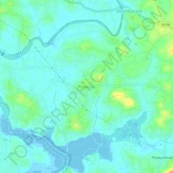
Name: Pinarayi topographic map, elevation, terrain.
Location: Pinarayi, Thalassery, Kannur, Kerala, 670741, India (11.79025 75.47476 11.83025 75.51476)
Average elevation: 12 m
Minimum elevation: -4 m
Maximum elevation: 59 m
Thank you for supporting this site ❤️
Make a donation
Make a donation
Other topographic maps
Click on a map to view its topography, its elevation and its terrain.
Thank you for supporting this site ❤️
Make a donation
Make a donation
Thank you for supporting this site ❤️
Make a donation
Make a donation
Thank you for supporting this site ❤️
Make a donation
Make a donation