
Sedibeng District Municipality topographic map
Interactive map
Click on the map to display elevation.
About this map
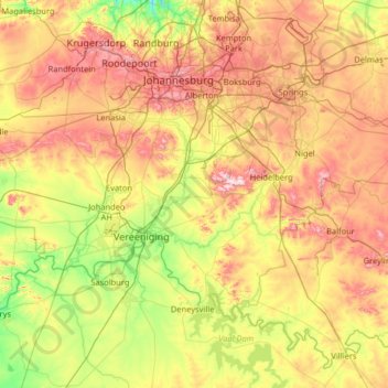
Name: Sedibeng District Municipality topographic map, elevation, terrain.
Location: Sedibeng District Municipality, Gauteng, South Africa (-26.92383 27.56909 -26.17224 28.86129)
Average elevation: 1,554 m
Minimum elevation: 1,346 m
Maximum elevation: 1,902 m
Other topographic maps
Click on a map to view its topography, its elevation and its terrain.
Lenasia
South Africa > Gauteng > City of Johannesburg Metropolitan Municipality
Average elevation: 1,590 m
Johannesburg
South Africa > Gauteng > City of Johannesburg Metropolitan Municipality
Johannesburg is located in the eastern plateau area of South Africa known as the Highveld, at an elevation of 1,753 metres (5,751 ft). The former Central Business District is located on the southern side of the prominent ridge called the Witwatersrand (English: White Water's Ridge) and the terrain falls to the…
Average elevation: 1,615 m
Diepsloot
South Africa > Gauteng > City of Johannesburg Metropolitan Municipality
Average elevation: 1,407 m
Alberton
South Africa > Gauteng > City of Ekurhuleni Metropolitan Municipality
Alberton lies at an elevation of approximately 1,570 m (5,150 ft) above sea level on the banks of the Natal Spruit, approximately 11 km south-east of Johannesburg CBD, 59 km south of Pretoria and 49 km north-east of Vereeniging. Organisationally and administratively, it is included in the City of Ekurhuleni…
Average elevation: 1,628 m
Magaliesburg
South Africa > Gauteng > West Rand District Municipality > Mogale City Local Municipality
Average elevation: 1,504 m
Randburg
South Africa > Gauteng > City of Johannesburg Metropolitan Municipality
Average elevation: 1,569 m
Benoni
South Africa > Gauteng > City of Ekurhuleni Metropolitan Municipality
Average elevation: 1,645 m
Vereeniging
South Africa > Gauteng > Sedibeng District Municipality > Vereeniging
Average elevation: 1,475 m
Pienaars
South Africa > Gauteng > City of Tshwane Metropolitan Municipality > De Rust Caravan Park
Average elevation: 1,093 m