
Thank you for supporting this site ❤️
Make a donation
Make a donation
Pontremoli topographic map
Click on the map to display elevation.
Thank you for supporting this site ❤️
Make a donation
Make a donation
About this map
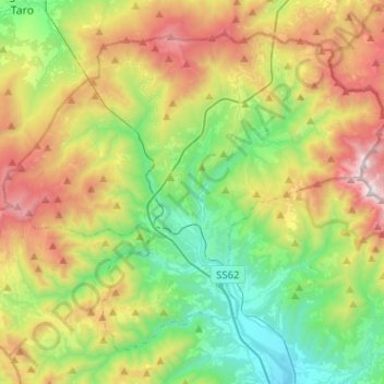
Name: Pontremoli topographic map, elevation, terrain.
Location: Pontremoli, Massa-Carrara, Tuscany, 54027, Italy (44.32159 9.75291 44.47254 10.00727)
Average elevation: 749 m
Minimum elevation: 124 m
Maximum elevation: 1,837 m
Thank you for supporting this site ❤️
Make a donation
Make a donation
Other topographic maps
Click on a map to view its topography, its elevation and its terrain.
Thank you for supporting this site ❤️
Make a donation
Make a donation
Thank you for supporting this site ❤️
Make a donation
Make a donation