
Mahébourg topographic map
Interactive map
Click on the map to display elevation.
About this map
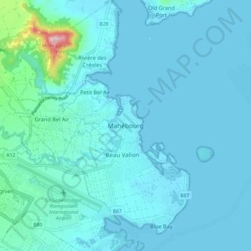
Name: Mahébourg topographic map, elevation, terrain.
Location: Mahébourg, Grand Port, 50812, Mauritius (-20.45110 57.66606 -20.37110 57.74606)
Average elevation: 30 m
Minimum elevation: 0 m
Maximum elevation: 359 m
Other topographic maps
Click on a map to view its topography, its elevation and its terrain.
Waterfront Mahebourg
Mauritius > Grand Port > Mahébourg
Waterfront Mahebourg, Parking Road, Mahebourg, Grand Port, Outer islands of Mauritius, 50810, Mauritius
Average elevation: 5 m