
Gemeinde Kaltenbach topographic map
Interactive map
Click on the map to display elevation.
About this map
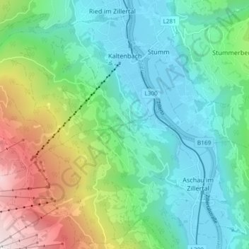
Name: Gemeinde Kaltenbach topographic map, elevation, terrain.
Location: Gemeinde Kaltenbach, Bezirk Schwaz, Tirol, 6272, Österreich (47.25502 11.81122 47.29905 11.88449)
Average elevation: 1,360 m
Minimum elevation: 549 m
Maximum elevation: 2,423 m
Kaltenbach ist über die Zillertalstraße B 169 und einen Bahnhof der Zillertalbahn angebunden. Außerdem kann von Kaltenbach aus auch der nördliche Endpunkt der Scheitelstrecke der Zillertaler Höhenstraße angefahren werden.
Other topographic maps
Click on a map to view its topography, its elevation and its terrain.
Pfaffenbichl
Österreich > Tirol > Bezirk Schwaz > Weerberg
Pfaffenbichl, Weerberg, Bezirk Schwaz, Tirol, Österreich
Average elevation: 2,086 m
21a
Österreich > Tirol > Bezirk Schwaz > Eben am Achensee
21a, Garberlalm, Eben am Achensee, Bezirk Schwaz, Tirol, 6215, Österreich
Average elevation: 1,269 m
Gemeinde Weerberg
Österreich > Tirol > Bezirk Schwaz
Gemeinde Weerberg, Bezirk Schwaz, Tirol, 6133, Österreich
Average elevation: 1,726 m
Schlitters
Österreich > Tirol > Bezirk Schwaz
Schlitters, Bezirk Schwaz, Tirol, 6262, Österreich
Average elevation: 814 m
Dornau
Österreich > Tirol > Bezirk Schwaz > Finkenberg
Dornau, Finkenberg, Bezirk Schwaz, Tirol, 6292, Österreich
Average elevation: 1,204 m
Gemeinde Buch in Tirol
Österreich > Tirol > Bezirk Schwaz
Gemeinde Buch in Tirol, Bezirk Schwaz, Tirol, 6220, Österreich
Average elevation: 913 m
Achensee
Österreich > Tirol > Bezirk Schwaz > Eben am Achensee > Pertisau
Achensee, Pertisau, Eben am Achensee, Bezirk Schwaz, Tirol, Österreich
Average elevation: 1,340 m
Mösl
Österreich > Tirol > Bezirk Schwaz > Gemeinde Hippach
Mösl, Gemeinde Hippach, Bezirk Schwaz, Tirol, 6283, Österreich
Average elevation: 1,655 m
Rotbachlspitze
Österreich > Tirol > Bezirk Schwaz > Gemeinde Finkenberg
Rotbachlspitze, Gemeinde Finkenberg, Bezirk Schwaz, Tirol, Österreich
Average elevation: 2,418 m
Strass im Zillertal
Österreich > Tirol > Bezirk Schwaz > Gemeinde Strass im Zillertal
Strass im Zillertal, Gemeinde Strass im Zillertal, Bezirk Schwaz, Tirol, 6261, Österreich
Average elevation: 638 m
Gedrechter
Österreich > Tirol > Bezirk Schwaz > Gemeinde Kaltenbach
Gedrechter, Gemeinde Kaltenbach, Bezirk Schwaz, Tirol, 6272, Österreich
Average elevation: 1,971 m
Zillergrund
Österreich > Tirol > Bezirk Schwaz > Gemeinde Brandberg
Zillergrund, Gemeinde Brandberg, Bezirk Schwaz, Tirol, 6290, Österreich
Average elevation: 1,913 m
Gemeinde Schwendau
Österreich > Tirol > Bezirk Schwaz
Gemeinde Schwendau, Bezirk Schwaz, Tirol, Österreich
Average elevation: 1,459 m
Gemeinde Wiesing
Österreich > Tirol > Bezirk Schwaz
Gemeinde Wiesing, Bezirk Schwaz, Tirol, 6210, Österreich
Average elevation: 852 m
Vorderunnutz
Österreich > Tirol > Bezirk Schwaz > Gemeinde Steinberg am Rofan
Vorderunnutz, Gemeinde Steinberg am Rofan, Bezirk Schwaz, Tirol, 6215, Österreich
Average elevation: 1,627 m
Weerberg
Österreich > Tirol > Bezirk Schwaz > Gemeinde Weerberg
Weerberg, Gemeinde Weerberg, Bezirk Schwaz, Tirol, 6133, Österreich
Average elevation: 873 m
Gerlos
Österreich > Tirol > Bezirk Schwaz > Gemeinde Gerlos
Gerlos, Gemeinde Gerlos, Bezirk Schwaz, Tirol, 6281, Österreich
Average elevation: 1,558 m
Olperer
Österreich > Tirol > Bezirk Schwaz > Gemeinde Tux
Olperer, Gemeinde Tux, Bezirk Schwaz, Tirol, Österreich
Average elevation: 2,935 m
Hochfügen
Österreich > Tirol > Bezirk Schwaz > Gemeinde Fügenberg
Hochfügen, Gemeinde Fügenberg, Bezirk Schwaz, Tirol, Österreich
Average elevation: 1,844 m
Buch in Tirol
Österreich > Tirol > Bezirk Schwaz > Gemeinde Buch in Tirol
Buch in Tirol, Gemeinde Buch in Tirol, Bezirk Schwaz, Tirol, 6222, Österreich
Average elevation: 718 m
Gemeinde Steinberg am Rofan
Österreich > Tirol > Bezirk Schwaz
Gemeinde Steinberg am Rofan, Bezirk Schwaz, Tirol, Österreich
Average elevation: 1,350 m
Gemeinde Gallzein
Österreich > Tirol > Bezirk Schwaz
Gemeinde Gallzein, Bezirk Schwaz, Tirol, 6222, Österreich
Average elevation: 1,275 m
Innerst
Österreich > Tirol > Bezirk Schwaz > Gemeinde Weerberg > Innerst
Innerst, Gemeinde Weerberg, Bezirk Schwaz, Tirol, 6133, Österreich
Average elevation: 1,529 m
Vomp
Österreich > Tirol > Bezirk Schwaz > Marktgemeinde Vomp
Vomp, Marktgemeinde Vomp, Bezirk Schwaz, Tirol, 6134, Österreich
Average elevation: 698 m
Holzalm
Österreich > Tirol > Bezirk Schwaz > Gemeinde Fügenberg > Hochfügen
Holzalm, Hochfügen, Gemeinde Fügenberg, Bezirk Schwaz, Tirol, Österreich
Average elevation: 1,860 m
Fügen
Österreich > Tirol > Bezirk Schwaz > Gemeinde Fügen > Fügen
Fügen, Gemeinde Fügen, Bezirk Schwaz, Tirol, 6362, Österreich
Average elevation: 737 m
Hollenzberg
Österreich > Tirol > Bezirk Schwaz > Marktgemeinde Mayrhofen
Hollenzberg, Marktgemeinde Mayrhofen, Bezirk Schwaz, Tirol, 6290, Österreich
Average elevation: 1,237 m
Hainzenberg
Österreich > Tirol > Bezirk Schwaz
Hainzenberg, Bezirk Schwaz, Tirol, 6278, Österreich
Average elevation: 1,588 m
Distelberg
Österreich > Tirol > Bezirk Schwaz > Gemeinde Aschau im Zillertal
Distelberg, Gemeinde Aschau im Zillertal, Bezirk Schwaz, Tirol, 6274, Österreich
Average elevation: 1,069 m
Tux
Österreich > Tirol > Bezirk Schwaz > Gemeinde Tux
Tux, Gemeinde Tux, Bezirk Schwaz, Tirol, 6293, Österreich
Average elevation: 1,625 m
Fügenberg
Österreich > Tirol > Bezirk Schwaz
Fügenberg, Bezirk Schwaz, Tirol, 6264, Österreich
Average elevation: 1,366 m
Hollenzen
Österreich > Tirol > Bezirk Schwaz > Marktgemeinde Mayrhofen > Hollenzen
Hollenzen, Marktgemeinde Mayrhofen, Bezirk Schwaz, Tirol, 6284, Österreich
Average elevation: 950 m
Marktgemeinde Mayrhofen
Österreich > Tirol > Bezirk Schwaz
Marktgemeinde Mayrhofen, Bezirk Schwaz, Tirol, Österreich
Average elevation: 1,983 m
Hart im Zillertal
Österreich > Tirol > Bezirk Schwaz
Hart im Zillertal, Bezirk Schwaz, Tirol, 6265, Österreich
Average elevation: 1,179 m
Fügen
Österreich > Tirol > Bezirk Schwaz
Fügen, Bezirk Schwaz, Tirol, Österreich
Average elevation: 771 m
Gemeinde Gerlosberg
Österreich > Tirol > Bezirk Schwaz
Gemeinde Gerlosberg, Bezirk Schwaz, Tirol, Österreich
Average elevation: 1,597 m
Hinterriß
Österreich > Tirol > Bezirk Schwaz > Vomp
Hinterriß, Vomp, Bezirk Schwaz, Tirol, Österreich
Average elevation: 1,246 m
Hintertux
Österreich > Tirol > Bezirk Schwaz > Gemeinde Tux
Hintertux, Gemeinde Tux, Bezirk Schwaz, Tirol, 6294, Österreich
Average elevation: 1,949 m
Schwaz
Österreich > Tirol > Bezirk Schwaz
Schwaz, Stadt Schwaz, Bezirk Schwaz, Tirol, 6130, Österreich
Average elevation: 951 m
Stummerberg
Österreich > Tirol > Bezirk Schwaz
Stummerberg, Bezirk Schwaz, Tirol, 6276, Österreich
Average elevation: 1,341 m