Geolocate

Altus topographic map

Interactive map

Click on the map to display elevation.

About this map

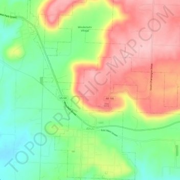
Name: Altus topographic map, elevation, terrain.

Location: Altus, Franklin County, Arkansas, 72821, United States (35.43244 -93.78921 35.48086 -93.74796)

Average elevation: 192 m

Minimum elevation: 112 m

Maximum elevation: 278 m

Altus had its start in 1875 when the railroad was extended to that point. Altus station was the highest point on the track. In recognition of this highest railroad elevation between Little Rock and Fort Smith, the station was originally known as "Summit". The town's initial development was due to railroad efforts encouraging German immigration to settle lands adjacent to the railroad. In 1903, the railroad mainline was shifted to a more favorable alignment along the Arkansas River. The track through Altus was removed in the 1930s, but the railroad station has been preserved as a commercial establishment.

Wikipedia (CC-BY-SA 3.0)

Other topographic maps

Click on a map to view its topography, its elevation and its terrain.

Charleston

United States > Arkansas > Franklin County

Charleston, Franklin County, Arkansas, United States

Average elevation: 156 m

Webb City

United States > Arkansas > Franklin County

Webb City, Franklin County, Arkansas, 72949, United States

Average elevation: 135 m

Vesta

United States > Arkansas > Franklin County

Vesta, Franklin County, Arkansas, United States

Average elevation: 147 m

Cecil

United States > Arkansas > Franklin County

Cecil, Franklin County, Arkansas, 72930, United States

Average elevation: 233 m

Branch

United States > Arkansas > Franklin County

Branch, Franklin County, Arkansas, 72928, United States

Average elevation: 148 m

Peanut

United States > Arkansas > Franklin County

Peanut, Franklin County, Arkansas, United States

Average elevation: 372 m

Alix

United States > Arkansas > Franklin County

Alix, Franklin County, Arkansas, 72820, United States

Average elevation: 129 m

Denning

United States > Arkansas > Franklin County

Denning, Franklin County, Arkansas, 72821, United States

Average elevation: 139 m

Wiederkehr Village

United States > Arkansas > Franklin County

Wiederkehr Village, Franklin County, Arkansas, United States

Average elevation: 209 m

Ozark

United States > Arkansas > Franklin County

Ozark, Franklin County, Arkansas, 72949, United States

Average elevation: 167 m

Redding

United States > Arkansas > Franklin County > Redding

Redding, Franklin County, Arkansas, United States

Average elevation: 308 m