
Ludzas novads topographic map
Interactive map
Click on the map to display elevation.
About this map
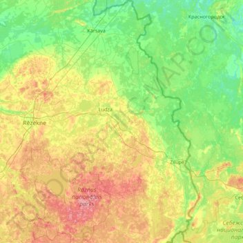
Name: Ludzas novads topographic map, elevation, terrain.
Location: Ludzas novads, Latgale, Letland (56.13647 27.34508 56.88013 28.24149)
Average elevation: 135 m
Minimum elevation: 82 m
Maximum elevation: 274 m
Other topographic maps
Click on a map to view its topography, its elevation and its terrain.
Priedaine
Letland > Latgale > Krāslavas novads > Krāslava
Priedaine, Krāslava, Krāslavas novads, Latgale, LV-5601, Letland
Average elevation: 129 m
Indrica
Letland > Latgale > Krāslavas novads
Indrica, Krāslavas novads, Latgale, Letland
Average elevation: 157 m
Saulkrasti
Letland > Latgale > Saulkrasti
Saulkrasti, Krāslavas novads, Latgale, Letland
Average elevation: 132 m