
Leeuwarden topographic map
Interactive map
Click on the map to display elevation.
About this map
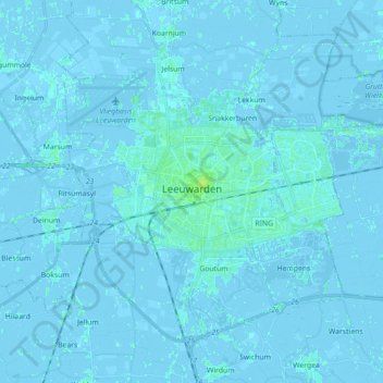
Name: Leeuwarden topographic map, elevation, terrain.
Location: Leeuwarden, Frisia, Netherlands (53.15830 5.72977 53.24110 5.90710)
Average elevation: 0 m
Minimum elevation: -4 m
Maximum elevation: 9 m
Other topographic maps
Click on a map to view its topography, its elevation and its terrain.
Leeuwarden
Netherlands > Frisia > Leeuwarden
Leeuwarden, Frisia, Netherlands, 8911BR, Netherlands
Average elevation: 0 m
Wolvega
Netherlands > Frisia > Wolvega > Wolvega
Wolvega, Weststellingwerf, Frisia, Netherlands, 8471JA, Netherlands
Average elevation: 1 m
Schiermonnikoog
Netherlands > Frisia > Schiermonnikoog
Schiermonnikoog, Frisia, Netherlands
Average elevation: 0 m
De Marne
Netherlands > Frisia > Schettens > Viersprong
De Marne, Viersprong, Schettens, Súdwest-Fryslân, Frisia, Netherlands, 8744 ES, Netherlands
Average elevation: -1 m
Sneek
Netherlands > Frisia > Sneek > Sneek
Sneek, Súdwest-Fryslân, Frisia, Netherlands, 8601CL, Netherlands
Average elevation: 0 m
Bolsward
Netherlands > Frisia > Bolsward > Bolsward
Bolsward, Súdwest-Fryslân, Frisia, Netherlands, 8701HZ, Netherlands
Average elevation: -1 m