
Zion National Park topographic map
Interactive map
Click on the map to display elevation.
About this map
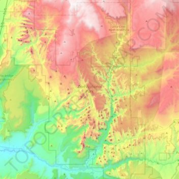
Name: Zion National Park topographic map, elevation, terrain.
Average elevation: 1,877 m
Minimum elevation: 1,055 m
Maximum elevation: 2,876 m
Der Zion-Nationalpark befindet sich im Südwesten Utahs an der Grenze zu Arizona. Er hat eine Fläche von 579 km² und liegt zwischen 1128 m (Coalpits Wash) und 2660 m Höhe (Horse Ranch Mountain). 1909 wurde das Gebiet des Canyons zum Mukuntuweap National Monument ernannt, seit 1919 besitzt es den Status eines Nationalparks. Der Park wurde 1937 um die Kolob Canyons erweitert.
Other topographic maps
Click on a map to view its topography, its elevation and its terrain.
Angels Landing
Vereinigte Staaten von Amerika > Utah > Washington County
Angels Landing, Washington County, Utah, Vereinigte Staaten von Amerika
Average elevation: 1,695 m
St. George
Vereinigte Staaten von Amerika > Utah > Washington County
St. George, Washington County, Utah, Vereinigte Staaten von Amerika
Average elevation: 929 m