
Angels Landing topographic map
Interactive map
Click on the map to display elevation.
About this map
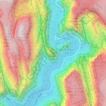
Name: Angels Landing topographic map, elevation, terrain.
Average elevation: 1,695 m
Minimum elevation: 1,303 m
Maximum elevation: 2,116 m
Other topographic maps
Click on a map to view its topography, its elevation and its terrain.
Zion National Park
Vereinigte Staaten von Amerika > Utah > Washington County
Zion National Park, Washington County, Utah, Vereinigte Staaten von Amerika
Average elevation: 1,877 m
St. George
Vereinigte Staaten von Amerika > Utah > Washington County
St. George, Washington County, Utah, Vereinigte Staaten von Amerika
Average elevation: 929 m