
Thank you for supporting this site ❤️
Make a donation
Make a donation
Cotati topographic map
Click on the map to display elevation.
Thank you for supporting this site ❤️
Make a donation
Make a donation
About this map
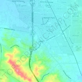
Name: Cotati topographic map, elevation, terrain.
Location: Cotati, Sonoma County, California, 94931, United States (38.31499 -122.72953 38.34313 -122.68777)
Average elevation: 42 m
Minimum elevation: 26 m
Maximum elevation: 128 m
Thank you for supporting this site ❤️
Make a donation
Make a donation
Other topographic maps
Click on a map to view its topography, its elevation and its terrain.
Fort Ross
United States > California > Sonoma County > Fort Ross
The Native Alaskan Village site was the subject of an investigation into its spatial organization, seeing “topographic mapping of surface features, systematic surface collection and generation of artifact distribution maps, and geophysical investigations involving both magnetometer and soil resistance…
Average elevation: 68 m