
Make a donation
Gillingham topographic map
Click on the map to display elevation.
Make a donation
About this map
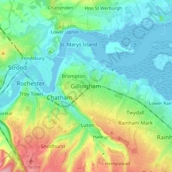
Name: Gillingham topographic map, elevation, terrain.
Location: Gillingham, Kent, England, ME7 5FA, United Kingdom (51.34717 0.50616 51.42717 0.58616)
Average elevation: 40 m
Minimum elevation: -2 m
Maximum elevation: 146 m
Make a donation
Other topographic maps
Click on a map to view its topography, its elevation and its terrain.
Make a donation
Barden Lake
United Kingdom > England > Kent > Tonbridge and Malling > Tonbridge
Average elevation: 33 m
Paul's Lake
United Kingdom > England > Kent > Dartford > Sutton at Hone > Lane End
Average elevation: 34 m
Make a donation
Make a donation
Make a donation
Make a donation
Make a donation
Make a donation
Make a donation
Make a donation
Make a donation
Make a donation
Make a donation
Make a donation
Make a donation
Make a donation
Make a donation
Romney, Hythe and Dymchurch Railway
United Kingdom > England > Kent > Folkestone and Hythe > St. Mary in the Marsh
Average elevation: 1 m
Make a donation
Kings Hill
United Kingdom > England > Kent > Tonbridge and Malling > Kings Hill
Average elevation: 82 m
Make a donation
Make a donation
Stelling Minnis
United Kingdom > England > Kent > Folkestone and Hythe District
Average elevation: 135 m
Sevenoaks Weald
United Kingdom > England > Kent > Sevenoaks > Sevenoaks Weald
Average elevation: 112 m
Make a donation
Make a donation
Faversham Creek
United Kingdom > England > Kent > Borough of Swale > Faversham > Oare
Average elevation: 11 m
Make a donation
St Margaret's Bay
United Kingdom > England > Kent > Dover > St. Margaret's at Cliffe
Average elevation: 38 m
Make a donation
Make a donation
Make a donation