
Make a donation
Yanshiping Town topographic map
Click on the map to display elevation.
Make a donation
Yanshiping Town
Yanshiping (Chinese: 雁石坪镇; pinyin: Yànshípíng zhèn) is a small town physically situated in the southwest of Qinghai province, China. However, it is under the jurisdiction of Amdo County in the Nagqu Prefecture of the Tibet Autonomous Region. At an elevation of 4,720 metres (15,490 ft), it is one of the highest permanent settlements in the world.
Make a donation
About this map
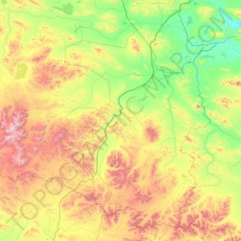
Name: Yanshiping Town topographic map, elevation, terrain.
Location: Yanshiping Town, Amdo County, Nagqu City, Tibet, China (32.82185 91.10172 34.21776 93.22680)
Average elevation: 4,958 m
Minimum elevation: 4,445 m
Maximum elevation: 6,425 m
Make a donation
Other topographic maps
Click on a map to view its topography, its elevation and its terrain.
Tanggula Mountains
China > Tibet > Amdo County > Yanshiping Town
The elevations of the main ridge average over 5,000 m (16,404 ft). The Yangtze River originates in this mountain range; Geladandong, 6,621 metres or 21,722 feet high, located in Tanggula Town, is the tallest peak in the range.
Average elevation: 5,912 m