
Mlaih Sub-District topographic map
Interactive map
Click on the map to display elevation.
About this map
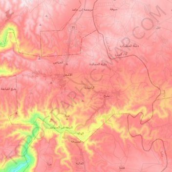
Name: Mlaih Sub-District topographic map, elevation, terrain.
Location: Mlaih Sub-District, Dieban District, Madaba, Jordan (31.54489 35.68325 31.64779 35.86679)
Average elevation: 663 m
Minimum elevation: 175 m
Maximum elevation: 854 m
Other topographic maps
Click on a map to view its topography, its elevation and its terrain.
Faisaliah Sub-District
Faisaliah Sub-District, Madaba Qasabah District, Madaba, Jordan
Average elevation: 485 m