
ໝື່ນ topographic map
Interactive map
Click on the map to display elevation.
About this map
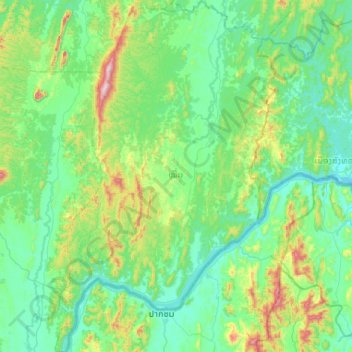
Name: ໝື່ນ topographic map, elevation, terrain.
Location: ໝື່ນ, Province de Vientiane, Laos (17.96846 101.72331 18.46444 102.05157)
Average elevation: 342 m
Minimum elevation: 170 m
Maximum elevation: 1,090 m
Other topographic maps
Click on a map to view its topography, its elevation and its terrain.
Phonepheng
Laos > Province de Vientiane > ວັງວຽງ
Phonepheng, ວັງວຽງ, Province de Vientiane, 30600, Laos
Average elevation: 255 m
ວັງວຽງ
Laos > Province de Vientiane > ວັງວຽງ
ວັງວຽງ, Province de Vientiane, 00008, Laos
Average elevation: 308 m