
Pamplemousses topographic map
Interactive map
Click on the map to display elevation.
About this map
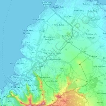
Name: Pamplemousses topographic map, elevation, terrain.
Location: Pamplemousses, Mauritius (-20.19777 57.49584 -19.99995 57.64871)
Average elevation: 92 m
Minimum elevation: -1 m
Maximum elevation: 747 m
Other topographic maps
Click on a map to view its topography, its elevation and its terrain.
Curepipe
Mauritius > Plaines Wilhems > Curepipe
Curepipe (Mauritian Creole pronunciation: ) also known as La Ville-Lumière (The City of Light), is a town in Mauritius, located in the Plaines Wilhems District, the eastern part also lies in the Moka District. The town is administered by the Municipal Council of Curepipe. Curepipe lies at a higher elevation,…
Average elevation: 511 m