
Thank you for supporting this site ❤️
Make a donation
Make a donation
Bagnell topographic map
Click on the map to display elevation.
Thank you for supporting this site ❤️
Make a donation
Make a donation
About this map
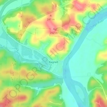
Name: Bagnell topographic map, elevation, terrain.
Location: Bagnell, Miller County, Missouri, United States (38.22241 -92.61665 38.23529 -92.59561)
Average elevation: 198 m
Minimum elevation: 165 m
Maximum elevation: 246 m
Thank you for supporting this site ❤️
Make a donation
Make a donation
Other topographic maps
Click on a map to view its topography, its elevation and its terrain.