
Xitle topographic map
Interactive map
Click on the map to display elevation.
About this map
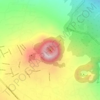
Name: Xitle topographic map, elevation, terrain.
Location: Xitle, Tlalpan, Mexiko-Stadt, 14273, Mexiko (19.24698 -99.22208 19.24708 -99.22198)
Average elevation: 2,912 m
Minimum elevation: 2,718 m
Maximum elevation: 3,096 m
Other topographic maps
Click on a map to view its topography, its elevation and its terrain.
Mexiko-Stadt
Mexiko > Mexiko-Stadt > Mexiko-Stadt
Mexiko-Stadt, Cuauhtémoc, Mexiko-Stadt, 06060, Mexiko
Average elevation: 2,321 m