
Zhuozhou City topographic map
Interactive map
Click on the map to display elevation.
About this map
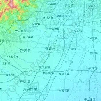
Name: Zhuozhou City topographic map, elevation, terrain.
Location: Zhuozhou City, Baoding City, Hebei, China (39.35098 115.73768 39.59986 116.24213)
Average elevation: 55 m
Minimum elevation: 17 m
Maximum elevation: 1,030 m
Other topographic maps
Click on a map to view its topography, its elevation and its terrain.
Dongguang County
Dongguang County, Cangzhou, Hebei, 061600, China
Average elevation: 14 m
Caofeidian District
Caofeidian District, Tangshan, Hebei, 063210, China
Average elevation: 1 m
Chongli District
China > Hebei > Zhangjiakou
Chongli District, Zhangjiakou, Hebei, 076300, China
Average elevation: 1,448 m
Shuangta Subdistrict
China > Hebei > Zhuozhou City
Shuangta Subdistrict, Zhuozhou City, Baoding City, Hebei, China
Average elevation: 34 m