
Make a donation
Essex topographic map
Click on the map to display elevation.
Make a donation
About this map
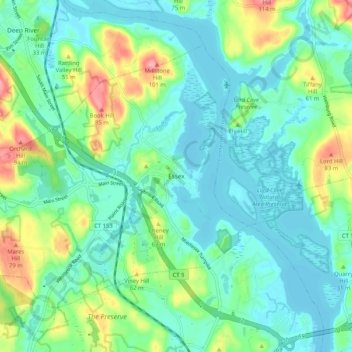
Name: Essex topographic map, elevation, terrain.
Average elevation: 26 m
Minimum elevation: -1 m
Maximum elevation: 100 m
Make a donation
Other topographic maps
Click on a map to view its topography, its elevation and its terrain.
Lake Pocotopaug
United States > Connecticut > Lower Connecticut River Valley Planning Region > East Hampton
Average elevation: 184 m
Essex Village
United States > Connecticut > Lower Connecticut River Valley Planning Region > Essex
Average elevation: 22 m
Pond Meadow
United States > Connecticut > Lower Connecticut River Valley Planning Region > Westbrook
Average elevation: 53 m
Field Park
United States > Connecticut > Lower Connecticut River Valley Planning Region > Middletown > Newfield Heights
Average elevation: 39 m
Make a donation
Goodspeeds Landing
United States > Connecticut > Lower Connecticut River Valley Planning Region > East Haddam
Average elevation: 52 m
Oxford Park
United States > Connecticut > Lower Connecticut River Valley Planning Region > Cromwell
Average elevation: 32 m
Chester Center
United States > Connecticut > Lower Connecticut River Valley Planning Region > Chester
Average elevation: 52 m
Pameacha Pond
United States > Connecticut > Lower Connecticut River Valley Planning Region > Middletown
Average elevation: 41 m
Make a donation
Dooley Pond
United States > Connecticut > Lower Connecticut River Valley Planning Region > Middletown
Average elevation: 97 m