
Thank you for supporting this site ❤️
Make a donation
Make a donation
Pond Meadow topographic map
Click on the map to display elevation.
Thank you for supporting this site ❤️
Make a donation
Make a donation
About this map
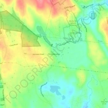
Name: Pond Meadow topographic map, elevation, terrain.
Average elevation: 53 m
Minimum elevation: 17 m
Maximum elevation: 102 m
Thank you for supporting this site ❤️
Make a donation
Make a donation
Other topographic maps
Click on a map to view its topography, its elevation and its terrain.
Westbrook Center
United States > Connecticut > Lower Connecticut River Valley Planning Region > Westbrook
Average elevation: 7 m