
สันปูเลย topographic map
Interactive map
Click on the map to display elevation.
About this map
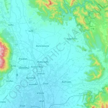
Name: สันปูเลย topographic map, elevation, terrain.
Location: สันปูเลย, Province de Chiang Mai, 50220, Thaïlande (18.66800 98.92084 18.98800 99.24084)
Average elevation: 379 m
Minimum elevation: 294 m
Maximum elevation: 1,207 m
Other topographic maps
Click on a map to view its topography, its elevation and its terrain.
บ้านศีรษะอาท
Thaïlande > Province de Chiang Mai > บ้านศีรษะอาท
บ้านศีรษะอาท, Province de Chiang Mai, Thaïlande
Average elevation: 409 m