
Alligny-en-Morvan topographic map
Interactive map
Click on the map to display elevation.
About this map
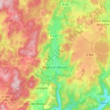
Name: Alligny-en-Morvan topographic map, elevation, terrain.
Average elevation: 561 m
Minimum elevation: 406 m
Maximum elevation: 706 m
Other topographic maps
Click on a map to view its topography, its elevation and its terrain.
L'Étang des Puits
France > Bourgogne-Franche-Comté > Nièvre > Alligny-en-Morvan > L'Étang des Puits
L'Étang des Puits, Alligny-en-Morvan, Château-Chinon (Ville), Nièvre, Bourgogne-Franche-Comté, France métropolitaine, 58230, France
Average elevation: 554 m