
Make a donation
Guelph topographic map
Click on the map to display elevation.
Make a donation
Guelph
This region of Ontario has cold winters and warm, humid summers, falling into the Köppen climate classification Dfb zone (humid continental), with moderately high rainfall and snowfall. It is generally a couple of degrees cooler than lower elevation regions on the Great Lakes shorelines, especially so in winter, the exception being on some spring afternoons when the lack of an onshore breeze boosts temperatures well above those found lakeside.
Make a donation
About this map
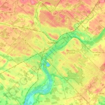
Name: Guelph topographic map, elevation, terrain.
Location: Guelph, Ontario, Canada (43.47382 -80.32691 43.59435 -80.15350)
Average elevation: 335 m
Minimum elevation: 292 m
Maximum elevation: 373 m
Make a donation
Other topographic maps
Click on a map to view its topography, its elevation and its terrain.
Toronto
Despite its deep ravines, Toronto is not remarkably hilly, but its elevation does increase steadily away from the lake. Elevation differences range from 76.5 metres (251 ft) above sea level at the Lake Ontario shore to 209 m (686 ft) ASL near the York University grounds in the city's north end at the…
Average elevation: 113 m
Make a donation
Dog Lake
Canada > Ontario > Thunder Bay District > Unorganized Thunder Bay District
Average elevation: 310 m
London
London has a humid continental climate (Köppen Dfb), though due to its downwind location relative to Lake Huron and elevation changes across the city, it is virtually on the Dfa/Dfb (hot summer) boundary favouring the former climate zone to the southwest of the confluence of the South and North Thames Rivers,…
Average elevation: 269 m
Make a donation
Apple Hill
Canada > Ontario > Stormont, Dundas and Glengarry Counties > North Glengarry
Average elevation: 90 m
Make a donation
Shabuskwia Lake
Canada > Ontario > Thunder Bay District > Unorganized Thunder Bay District
Average elevation: 332 m
Make a donation
The International Falls
Canada > Ontario > Rainy River District > Fort Frances
Average elevation: 341 m
Make a donation
Plattsville
Canada > Ontario > Oxford County > Blandford-Blenheim > Plattsville
Average elevation: 315 m
Make a donation