
Agra topographic map
Interactive map
Click on the map to display elevation.
About this map
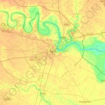
Name: Agra topographic map, elevation, terrain.
Location: Agra, Agra District, Uttar Pradesh, India (27.04720 77.85178 27.29598 78.22094)
Average elevation: 166 m
Minimum elevation: 143 m
Maximum elevation: 181 m
The region around Agra consists almost entirely of a level plain, with hills in the extreme southwest. The rivers in the region include Yamuna and Chambal. The region is also watered by the Agra Canal. Millet, barley, wheat and cotton are among the crops grown in the surrounding countryside. Both Rabi and Kharif crops are cultivated. The deserted city of Fatehpur Sikri is about 40 km southwest of Agra. The sandstone hills near Fatehpur Sikri and on the south-eastern borders of the district are offshoots from the Vindhya range of Central India. Agra is about 210 km away from the National capital of New Delhi(via Yamuna Expressway), about 336 km from state capital Lucknow(via Agra-Lucknow Expressway), and about 227 km from Kanpur(via Agra-Lucknow Expressway). The city has an average elevation of 170 metres above sea level.
Other topographic maps
Click on a map to view its topography, its elevation and its terrain.
Noida
India > Uttar Pradesh > Dadri
Noida, Dadri, Gautam Buddha Nagar District, Uttar Pradesh, 201301, India
Average elevation: 216 m
Babhnan
India > Uttar Pradesh > Harraiya
Babhnan, Harraiya, Basti District, Uttar Pradesh, India
Average elevation: 94 m
Chandauli
India > Uttar Pradesh > Chandauli
Chandauli, Chandauli District, Uttar Pradesh, 232104, India
Average elevation: 76 m
Baghpat
India > Uttar Pradesh > Baghpat
Baghpat, Baghpat District, Uttar Pradesh, 250609, India
Average elevation: 219 m
Gorakhpur
Gorakhpur, Gorakhpur District, Uttar Pradesh, 273165, India
Average elevation: 90 m
Mirzapur
India > Uttar Pradesh > Mirzapur
Mirzapur, Uttar Pradesh, 231001, India
Average elevation: 83 m
Dankaur
India > Uttar Pradesh > Gautam Buddha Nagar
Dankaur, Gautam Buddha Nagar, Gautam Buddha Nagar District, Uttar Pradesh, 203200, India
Average elevation: 197 m
Kishorpur
India > Uttar Pradesh > Jewar
Kishorpur, Jewar, Gautam Buddha Nagar District, Uttar Pradesh, 203155, India
Average elevation: 198 m
Saharanpur
Saharanpur, Saharanpur District, Uttar Pradesh, India
Average elevation: 287 m
Agwanpur
India > Uttar Pradesh > Moradabad
Agwanpur, Moradabad, Moradabad District, Uttar Pradesh, India
Average elevation: 203 m
Ayodhya
India > Uttar Pradesh > Faizabad
Ayodhya, Faizabad, Ayodhya District, Uttar Pradesh, 224123, India
Average elevation: 96 m
Bakshi Ka Talab
Bakshi Ka Talab, Lucknow District, Uttar Pradesh, India
Average elevation: 122 m
Barabanki
India > Uttar Pradesh > Nawabganj
Barabanki, Nawabganj, Barabanki District, Uttar Pradesh, 225001, India
Average elevation: 118 m
Farrukhabad
India > Uttar Pradesh > Farrukhabad
Farrukhabad, Farrukhabad District, Uttar Pradesh, 209625, India
Average elevation: 146 m
Kharkhauda
Kharkhauda, Meerut District, Uttar Pradesh, 245206, India
Average elevation: 219 m
Lucknow
India > Uttar Pradesh > Lucknow
Lucknow, Lucknow District, Uttar Pradesh, 226027, India
Average elevation: 120 m
Markundi
India > Uttar Pradesh > Robertsganj
Markundi, Robertsganj, Sonbhadra District, Uttar Pradesh, 231209, India
Average elevation: 302 m
Sultanpur Dost
India > Uttar Pradesh > Thakurdwara
Sultanpur Dost, Thakurdwara, Moradabad District, Uttar Pradesh, India
Average elevation: 214 m
Sabalpur
India > Uttar Pradesh > Thakurdwara > Dulhepur Patti Jat
Sabalpur, Dulhepur Patti Jat, Thakurdwara, Moradabad District, Uttar Pradesh, India
Average elevation: 228 m
Susuwahi
India > Uttar Pradesh > Sadar > Varanasi
Susuwahi, Varanasi, Sadar, Varanasi District, Uttar Pradesh, 221011, India
Average elevation: 80 m
Kheria
India > Uttar Pradesh > Agra
Kheria, Agra, Agra District, Uttar Pradesh, 282001, India
Average elevation: 167 m
Farah
India > Uttar Pradesh > Mathura District
Farah, Mathura, Mathura District, Uttar Pradesh, 281112, India
Average elevation: 172 m
Gandhi Udhyan
India > Uttar Pradesh > Bareilly > Bareilly
Gandhi Udhyan, Bareilly, Bareilly District, Uttar Pradesh, 243001, India
Average elevation: 175 m
Dewal
India > Uttar Pradesh > Zamania
Dewal, Zamania, Ghazipur District, Uttar Pradesh, India
Average elevation: 66 m
Tiwariganj
India > Uttar Pradesh > Lucknow
Tiwariganj, Lucknow, Lucknow District, Uttar Pradesh, 226028, India
Average elevation: 117 m
Hastinapur
India > Uttar Pradesh > Mawana
Hastinapur, Mawana, Meerut District, Uttar Pradesh, 250404, India
Average elevation: 226 m
Meerut
Meerut, Meerut District, Uttar Pradesh, 250003, India
Average elevation: 225 m
Hazipur
India > Uttar Pradesh > Dadri
Hazipur, Dadri, Gautam Buddha Nagar District, Uttar Pradesh, 201303, India
Average elevation: 199 m
Siddharthnagar District
Siddharthnagar District, Uttar Pradesh, India
Average elevation: 93 m
Marihan
Marihan, Mirzapur District, Uttar Pradesh, 231310, India
Average elevation: 205 m
Varanasi
India > Uttar Pradesh > Sadar
Varanasi, Sadar, Varanasi District, Uttar Pradesh, 221001, India
Average elevation: 77 m
Kheri
India > Uttar Pradesh > Lakhimpur
Kheri, Lakhimpur, Lakhimpur Kheri District, Uttar Pradesh, 262700, India
Average elevation: 144 m
Kānpur
Kānpur, Kanpur Dehat District, Uttar Pradesh, India
Average elevation: 130 m
Lalitpur
Lalitpur, Lalitpur District, Uttar Pradesh, India
Average elevation: 396 m
Kaushambi
India > Uttar Pradesh > Manjhanpur > Gadhva
Kaushambi, Gadhva, Manjhanpur, Kaushambi District, Uttar Pradesh, India
Average elevation: 92 m
Balrampur
Balrampur, Balrampur District, Uttar Pradesh, India
Average elevation: 136 m
Bahraich
India > Uttar Pradesh > Bahraich
Bahraich, Bahraich District, Uttar Pradesh, 271801, India
Average elevation: 120 m
Unchahar
Unchahar, Raebareli District, Uttar Pradesh, India
Average elevation: 108 m
Patti
India > Uttar Pradesh > Pratapgarh District
Patti, Pratapgarh District, Uttar Pradesh, India
Average elevation: 93 m
Sitapur
India > Uttar Pradesh > Sitapur
Sitapur, Sitapur District, Uttar Pradesh, 261001, India
Average elevation: 138 m