
Thank you for supporting this site ❤️
Make a donation
Make a donation
Haa District topographic map
Click on the map to display elevation.
Thank you for supporting this site ❤️
Make a donation
Make a donation
About this map
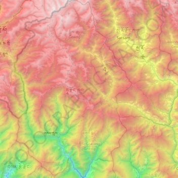
Name: Haa District topographic map, elevation, terrain.
Location: Haa District, Bhutan (27.02730 88.98297 27.57745 89.38574)
Average elevation: 3,039 m
Minimum elevation: 561 m
Maximum elevation: 5,583 m
Thank you for supporting this site ❤️
Make a donation
Make a donation
Other topographic maps
Click on a map to view its topography, its elevation and its terrain.
Jigmecholing town
Bhutan > Sarpang District > Jigme Chhoeling Gewog > Khamaed
Average elevation: 1,216 m
Thank you for supporting this site ❤️
Make a donation
Make a donation
Deothang
Bhutan > Samdrup Jongkhar District > Dewathang Gewog > Chhenangri_Rishor > Deothang
Average elevation: 660 m