
Thank you for supporting this site ❤️
Make a donation
Make a donation
Kaub topographic map
Click on the map to display elevation.
Thank you for supporting this site ❤️
Make a donation
Make a donation
About this map
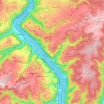
Name: Kaub topographic map, elevation, terrain.
Average elevation: 286 m
Minimum elevation: 67 m
Maximum elevation: 441 m
Thank you for supporting this site ❤️
Make a donation
Make a donation
Other topographic maps
Click on a map to view its topography, its elevation and its terrain.
Katz Castle
Germany > Rhineland-Palatinate > Rhein-Lahn-Kreis > Sankt Goarshausen > Heide
Average elevation: 178 m
Berghausen
Germany > Rhineland-Palatinate > Rhein-Lahn-Kreis > Berghausen > Berghausen
Average elevation: 336 m