
Trail Creek topographic map
Interactive map
Click on the map to display elevation.
About this map
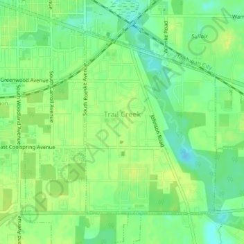
Name: Trail Creek topographic map, elevation, terrain.
Location: Trail Creek, LaPorte County, Indiana, United States (41.68737 -86.86479 41.70750 -86.84522)
Average elevation: 194 m
Minimum elevation: 183 m
Maximum elevation: 201 m
Other topographic maps
Click on a map to view its topography, its elevation and its terrain.
Michigan City
United States > Indiana > LaPorte County
Michigan City, LaPorte County, Indiana, United States
Average elevation: 188 m
Fish Lake
United States > Indiana > LaPorte County
Fish Lake, LaPorte County, Indiana, 46365, United States
Average elevation: 215 m
Kingsbury
United States > Indiana > LaPorte County
Kingsbury, LaPorte County, Indiana, 46345, United States
Average elevation: 227 m
Fish Creek
United States > Indiana > LaPorte County
Fish Creek, LaPorte County, Indiana, 46365, United States
Average elevation: 217 m
Long Beach
United States > Indiana > LaPorte County
Long Beach, LaPorte County, Indiana, United States
Average elevation: 184 m
La Porte
United States > Indiana > LaPorte County
La Porte, LaPorte County, Indiana, 46350, United States
Average elevation: 247 m