
Arkansas River topographic map
Interactive map
Click on the map to display elevation.
About this map
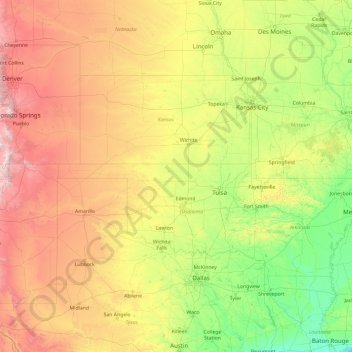
Name: Arkansas River topographic map, elevation, terrain.
Average elevation: 634 m
Minimum elevation: 0 m
Maximum elevation: 4,110 m
Other topographic maps
Click on a map to view its topography, its elevation and its terrain.
Alida
United States of America > Kansas > Alida
Alida, Geary County, Kansas, United States of America
Average elevation: 351 m