
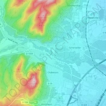
Châtenois topographic map
Interactive map
Click on the map to display elevation.
About this map
Name: Châtenois topographic map, elevation, terrain.
Average elevation: 243 m
Minimum elevation: 170 m
Maximum elevation: 521 m
Sous l'Empire romain, le village est connu sous le nom de Castinetum (de châtaigneraie, endroit planté de châtaigniers).Le nom de Châtenois est attesté sous les formes Villa Castineto en 1112, Castineto en 1138, Castiney en 1177, Kestenhoulz en 1189, Kestenholz en 1232, Scheckteney en 1241, Questenesholz en 1444, Köstenhol en 1599. En 1502, dans le livre Declaratio ad mitigandum adversarium écrit par Wimpheling, Châtenois est cité sous son le nom de Kestenholtz. Il en est de même dans le livre de Mathäus Merian, Topographia Germaniae, dans les actes paroissiaux de la commune à partir de 1685. En 1807, le village est connu sous sa forme actuelle, Châtenois, la traduction de son nom allemand et dialectal. En 1871, il est germanisé en Kestenholz, avant de reprendre son nom français après la Seconde Guerre mondiale.
Other topographic maps
Click on a map to view its topography, its elevation and its terrain.
Roethel
France > Grand Est > Bas-Rhin > Soufflenheim
Roethel, Soufflenheim, Haguenau-Wissembourg, Bas-Rhin, Grand Est, France métropolitaine, 67620, France
Average elevation: 126 m
Strasbourg
France > Grand Est > Bas-Rhin > Strasbourg
Strasbourg, Bas-Rhin, Grand Est, France métropolitaine, 67073, France
Average elevation: 154 m
Strasbourg
Strasbourg, Bas-Rhin, Grand Est, France métropolitaine, France
Average elevation: 144 m