Geolocate

Achenheim topographic map

Interactive map

Click on the map to display elevation.

About this map

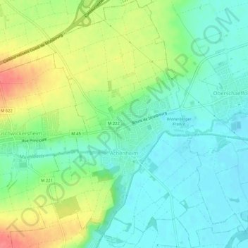
Name: Achenheim topographic map, elevation, terrain.

Location: Achenheim, Strasbourg, Bas-Rhin, Grand Est, France métropolitaine, 67204, France (48.56481 7.60873 48.59889 7.64947)

Average elevation: 166 m

Minimum elevation: 142 m

Maximum elevation: 210 m

Other topographic maps

Click on a map to view its topography, its elevation and its terrain.

Plaine

France > Grand Est > Bas-Rhin

Plaine, Molsheim, Bas-Rhin, Grand Est, France métropolitaine, 67420, France

Average elevation: 579 m

Haut-Barr

France > Grand Est > Bas-Rhin > Saverne

Haut-Barr, Le Pont du Diable, Saverne, Bas-Rhin, Grand Est, France métropolitaine, 67700, France

Average elevation: 288 m

Roethel

France > Grand Est > Bas-Rhin > Soufflenheim

Roethel, Soufflenheim, Haguenau-Wissembourg, Bas-Rhin, Grand Est, France métropolitaine, 67620, France

Average elevation: 126 m

Strasbourg

France > Grand Est > Bas-Rhin > Strasbourg

Strasbourg, Bas-Rhin, Grand Est, France métropolitaine, 67073, France

Average elevation: 154 m

Erstein

France > Grand Est > Bas-Rhin > Erstein

Erstein, Sélestat-Erstein, Bas-Rhin, Grand Est, France métropolitaine, 67150, France

Average elevation: 152 m

Châtenois

France > Grand Est > Bas-Rhin

Châtenois, Sélestat-Erstein, Bas-Rhin, Grand Est, France métropolitaine, 67730, France

Average elevation: 243 m

Strasbourg

France > Grand Est > Bas-Rhin

Strasbourg, Bas-Rhin, Grand Est, France métropolitaine, France

Average elevation: 144 m