
Thank you for supporting this site ❤️
Make a donation
Make a donation
Constantine topographic map
Click on the map to display elevation.
Thank you for supporting this site ❤️
Make a donation
Make a donation
About this map
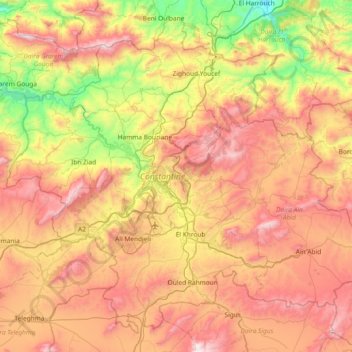
Name: Constantine topographic map, elevation, terrain.
Location: Constantine, Algeria (36.09257 6.30963 36.62426 7.04932)
Average elevation: 711 m
Minimum elevation: 75 m
Maximum elevation: 1,427 m
Thank you for supporting this site ❤️
Make a donation
Make a donation
Other topographic maps
Click on a map to view its topography, its elevation and its terrain.
Thank you for supporting this site ❤️
Make a donation
Make a donation
Thank you for supporting this site ❤️
Make a donation
Make a donation