
Thank you for supporting this site ❤️
Make a donation
Make a donation
Tytherington topographic map
Click on the map to display elevation.
Thank you for supporting this site ❤️
Make a donation
Make a donation
About this map
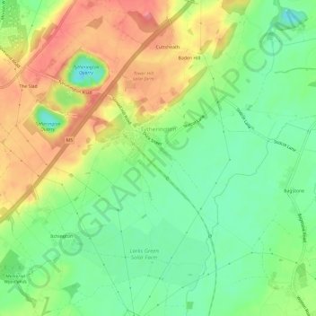
Name: Tytherington topographic map, elevation, terrain.
Average elevation: 68 m
Minimum elevation: 31 m
Maximum elevation: 115 m
Thank you for supporting this site ❤️
Make a donation
Make a donation
Other topographic maps
Click on a map to view its topography, its elevation and its terrain.
Goblin Ledge
United Kingdom > England > South Gloucestershire > Severn Beach > New Passage
Average elevation: 2 m
Buckover
United Kingdom > England > South Gloucestershire > Thornbury > Milbury Heath
Average elevation: 65 m
Thank you for supporting this site ❤️
Make a donation
Make a donation