
Thank you for supporting this site ❤️
Make a donation
Make a donation
Kingswood topographic map
Click on the map to display elevation.
Thank you for supporting this site ❤️
Make a donation
Make a donation
About this map
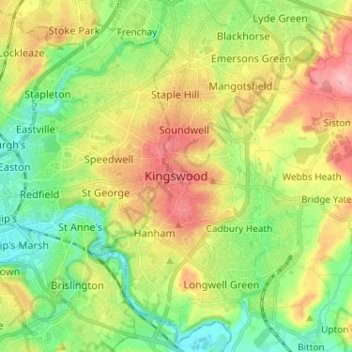
Name: Kingswood topographic map, elevation, terrain.
Average elevation: 57 m
Minimum elevation: 5 m
Maximum elevation: 131 m
Thank you for supporting this site ❤️
Make a donation
Make a donation
Other topographic maps
Click on a map to view its topography, its elevation and its terrain.
Thank you for supporting this site ❤️
Make a donation
Make a donation
Acton Turville
United Kingdom > England > South Gloucestershire > Acton Turville
Average elevation: 130 m
Thank you for supporting this site ❤️
Make a donation
Make a donation
Thank you for supporting this site ❤️
Make a donation
Make a donation