
Santiagu'l Monte topographic map
Interactive map
Click on the map to display elevation.
About this map
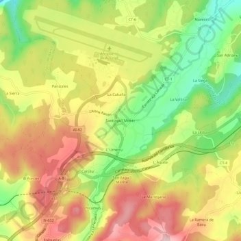
Name: Santiagu'l Monte topographic map, elevation, terrain.
Location: Santiagu'l Monte, Castrillón, Asturies, 33457, Espagne (43.52963 -6.04835 43.56963 -6.00835)
Average elevation: 121 m
Minimum elevation: 0 m
Maximum elevation: 231 m
Other topographic maps
Click on a map to view its topography, its elevation and its terrain.
Arancés
Espagne > Asturies > Castrillón > Piedrasblancas
Arancés, Piedrasblancas, Castrillón, Asturies, 33459, Espagne
Average elevation: 37 m