
Bellevue topographic map
Interactive map
Click on the map to display elevation.
About this map
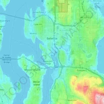
Name: Bellevue topographic map, elevation, terrain.
Location: Bellevue, King County, Washington, United States (47.53501 -122.22281 47.66079 -122.08722)
Average elevation: 66 m
Minimum elevation: -3 m
Maximum elevation: 455 m
Other topographic maps
Click on a map to view its topography, its elevation and its terrain.
Burien
United States > Washington > King County
Burien, King County, Washington, United States
Average elevation: 65 m
Twin Falls (Lower)
United States > Washington > King County
Twin Falls (Lower), King County, Washington, 98045, United States
Average elevation: 458 m
Covington
United States > Washington > King County
Covington, King County, Washington, 98042, United States
Average elevation: 137 m
Bothell
United States > Washington > King County > Bothell
Bothell, King County, Washington, United States
Average elevation: 68 m
Seattle
United States > Washington > King County
Seattle, King County, Washington, United States
Average elevation: 40 m