
Make a donation
Tlaxcala topographic map
Click on the map to display elevation.
Make a donation
Tlaxcala
Tlaxcala is a land-locked state situated on the Trans-Mexican Volcanic Belt. The average altitude for the state is 2,230 meters above sea level, making it a bit higher than the Valley of Mexico just to the southwest. The western part of the state lies on the central plateau of Mexico while the east is dominated by the Sierra Madre Oriental, home of the 4,461 meter La Malinche volcano. Most of the state is rugged terrain dominated by ridges and deep valleys, along with protruding igneous rock formations. This ruggedness, along with large-scale weather phenomena such as the Intertropical Convergence Zone, gives the state a complex climate. Overall rain patterns for the state are about 400 mm (16 in) in the summer rainy season and 30 mm (1.2 in) in the winter. Locally, however, this varies dramatically between the drier plateaus and valleys and the wetter mountains. Variations in altitude produce sub-climates between semi-tropical to temperate, with frosts likely in the higher elevations during the winter. Temperate fir (Abies religiosa), juniper (Juniperus deppeana), and pine-oak forests dominate the mountain highlands, while the flatlands, with their drier climate, are characterized by agaves and prickly pear cactus (Opuntia).
Make a donation
About this map
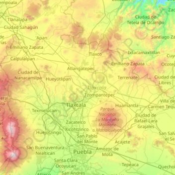
Name: Tlaxcala topographic map, elevation, terrain.
Location: Tlaxcala, Mexico (19.10507 -98.70840 19.72892 -97.62544)
Average elevation: 2,540 m
Minimum elevation: 1,279 m
Maximum elevation: 5,328 m
Make a donation
Other topographic maps
Click on a map to view its topography, its elevation and its terrain.
Paseo al Monte (Camino a la Boquilla)
Mexico > Zacatecas > Moyahua de Estrada > Moyahua de Estrada
Average elevation: 1,224 m
Texcoco de Mora
Mexico > State of Mexico > Texcoco
Tescoco lies about 25 km east of the centre of Mexico City. Major elevations in the municipality include the Tlaloc Mountain (4,500 meters) the Tetzcutzinco, Moyotepec and Tecuachacho. Most elevations are named after the major community to be found on them. There are also a number of small canyons. Part of the…
Average elevation: 2,262 m
Make a donation
Make a donation
Make a donation
Ciudad Victoria
Mexico > Tamaulipas > Victoria
Ciudad Victoria has a climate on the border of humid subtropical (Köppen Cfa/Cwa) and hot semi-arid (BSh). Its weather is characterised by short warm winters and long hot to sweltering summers. Temperatures rarely drop below 0 °C (32 °F) — the lowest recorded temperature was −6 °C (21.2 °F) and the…
Average elevation: 518 m
Make a donation
Make a donation
Hecelchakán
Mexico > Campeche > Hecelchakán
It is at an altitude of 10 m above sea level.
Average elevation: 34 m
Chihuahua
Mexico > Chihuahua > Municipio de Chihuahua
Chihuahua lies on the western side of the Chihuahuan Desert ecoregion and as such has a semiarid climate (Köppen climate classification BSh). However, it is not as hot as most of the lower elevated portions of the desert to the east owing to an altitude of almost 1,500 metres (4,900 feet) above sea level.
Average elevation: 1,555 m
Make a donation
Make a donation
Piedras Negras
Mexico > Coahuila > Municipio de Piedras Negras > Piedras Negras
Average elevation: 256 m
Make a donation