
Make a donation
Umnak Island topographic map
Click on the map to display elevation.
Make a donation
Umnak Island
Umnak, the third largest of the Aleutian Islands after Unimak and Unalaska, lies in the Fox Islands of the Aleutian Islands of the Bering Sea, to the southwest of the larger island of Unalaska. It is approximately 70–72 miles (113–116 km) in length (117 kilometres (73 mi)) and 16 miles (26 km) wide on average. The island was separated in the last glacial period and now lies about 300 kilometres (190 mi) from North American shores. It is an active volcanic island, with a land area of 1,793.2 km2 (692.4 sq mi) and with a coastline extending over 330.2 kilometres (205.2 mi). The elevation of the island is 2,132 metres (6,995 ft). The island is very mountainous with a low level of vegetation. The island does not have a harbor, although a sizeable bay is located in the western part of the island and contains the Adugak Island. The southern point of the island is known as Cape Sagak.
Make a donation
About this map
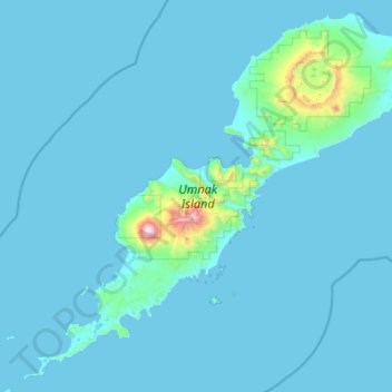
Name: Umnak Island topographic map, elevation, terrain.
Average elevation: 64 m
Minimum elevation: -3 m
Maximum elevation: 2,004 m
Make a donation
Other topographic maps
Click on a map to view its topography, its elevation and its terrain.
Make a donation
Make a donation
Mount Okmok
United States > Alaska > Unorganized Borough
After a period of quiescence, an intense eruption took place at Okmok in 43 BCE. A rhyodacitic eruption column rose over the volcano from a vent in its northern part. Pumice lapilli fell out from the eruption column. The fallout was emplaced in three distinct units, with a brief break between the first two…
Average elevation: 713 m
Make a donation
Make a donation
Mount Wrangell
United States > Alaska > Unorganized Borough
Modern Mount Wrangell, built upon the remnants of a mid-Pleistocene volcano, has an eruptive history spanning from 750,000 years ago to minor phreatic eruptions in 1884. The shield volcano features an ice-filled caldera 2.5 by 3.7 miles (4 by 6 km) in diameter at the top of Wrangell's broad summit. The caldera…
Average elevation: 4,013 m
Mount Blackburn
United States > Alaska > Unorganized Borough
Mount Blackburn is a large, dramatic peak, with great local relief and independence from higher peaks. Its west face drops over 11,000 ft (3,350 m) to the Kuskulana Glacier in less than 4 horizontal miles (6.4 km). Its other faces drop 8,000–10,000 ft (2,440–3,050 m), all in less than 8 miles (13 km). The…
Average elevation: 4,530 m
Make a donation
Mount Sanford
United States > Alaska > Unorganized Borough
Mount Sanford was first climbed on July 21, 1938 by noted mountaineers Terris Moore and Bradford Washburn, via the still-standard North Ramp route up the Sheep Glacier. This route "offers little technical difficulty" and "is a glacier hike all the way to the summit" but is still a serious mountaineering…
Average elevation: 4,221 m
Make a donation
Make a donation
Make a donation
Eagle Summit
United States > Alaska > Unorganized Borough
It was for this latter reason that engineers chose Eagle Summit as the route to build the Steese Highway, which connects Fairbanks, Alaska to the Yukon River at Circle. In 1927, just 11 years after Stuck became one of the first Americans to navigate Eagle Summit on dog sled, the highway was completed and road…
Average elevation: 1,068 m
Make a donation
Little Diomede Island
United States > Alaska > Unorganized Borough > Diomede > Diomede
Average elevation: 160 m
Make a donation
Make a donation
Make a donation
Make a donation
Kasatochi Island
United States > Alaska > Unorganized Borough
Kasatochi Island is a member of the Aleutian Islands, which lie above a narrow ridge that separates the Bering Sea from the North Pacific. It lies at the Atka Pass northwest of the western tip of Atka Island and east of Great Sitkin Island. It is at 52.177° N latitude and 175.508° W longitude, with a summit…
Average elevation: 53 m
Make a donation
Make a donation
Make a donation
Make a donation
Make a donation
Make a donation